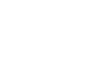
(Wyoming) Map K. 6 miles; moderate after an initial difficult climb of 300 feet. 45 mins. from Scranton
Take Route 6 to Tunkhannock. I~rn left at light at Prince Hotel and cross bridge. Turn left on first paved road. Parking area is a couple of miles down on left. You will see the Susquehanna River on the left.
Miller Mountain rises sharply on the right. Bushwack straight up and through the woods a short distance to an old grassy road where you will turn right. Proceed along this old road to a stand of red pine with a built-in picnic area waiting for you to take a short break. Continue on to top of mountain for good views of the valley. Bushwacking may be necessary at times but just keep going up. A trail across the top comes to a hunting cabin which is private property but the owner doesn't mind people using it to get out of the wind. Just leave it as you found it. Return via the same route.
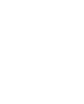
(Wayne) Map F 3 miles; easy. 30 mins from Scranton
Take Route 6 east of Carbondale and turn left on paved road just before first reservoir on left. Shortly you will come to an obvious railroad grade on right . Park near it, but do not block access
Follow railroad to stream coming from right at about one mile. Follow this up to right a few hundred yards to see interesting rock formations. Backtrack to railroad and continue to large stream with several waterfalls. Follow stream up to the right for a secluded swimming hole, but do wear shoes. There is glass in the bottom.